As was first reported last month by Techcrunch, Google Maps has created a way for cyclists to calculate elevation into their bike routes with their new “elevation profiles.” This new feature allows you to plan ahead for the elevation changes that you will encounter on your routes.
You can access this feature by simply going to the Google Maps website, enter in your origin and destination and click the cyclist icon in the map’s info box. A diagram will drop down that includes a graph. The graph will display the elevation fluctuation throughout the route, the highest and lowest elevation points, and the total elevation changes. You can determine the specific elevation calculations as you zoom in on the route. As expected, these elevation profiles do provide much information if the route chosen is flat.
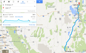
I calculated out the 398 mile trip from St. George to Logan, UT and discovered the route takes you as high as 6,955 feet and as low as 2,631 feet. It looks like 10,335 feet of the journey is a struggle uphill while 8,435 feet of it is a downward coast.
After choosing your route and then the cyclist option, Google Maps does a great job at showing routes that are bicycle friendly. They display different colored lines that show bicycle trails and lanes. They also recommend roads where it appears to be easier or more accessible to cyclists. You can choose which route you want to take, as with the car or walking routes. You also have the option to avoid areas (such as highways) or include areas (for scenery, lower/higher elevation) as you choose.
Apparently, Google implemented the feature quietly with no official announcement. According to Techcrunch, Google Maps offers elevation profiles in all 14 countries where they offer biking directions, including Austria, Australia, Belgium, Canada, Switzerland, Germany, Denmark, Finland, Great Britain, Netherlands, Norway, New Zealand, Sweden, and the United States.
Other websites that offer this feature include: veloroutes.org and cycleroute.org, both of which offer the ability to calculate bike routes with altitude.
Mobile Apps that Offer Elevation Tracking
As of yet, Google does not include this feature for IOS or mobile devices, though it most assuredly will in the future. Despite this setback, there are other mobile apps that have been recommended if you are hoping to plan out your route on the go:
- iMapMyRide+ – this app allows you to track your speed, distance, elevation and time. It also allows you the capacity to track your heart rate (additional purchase necessary) and then sync that data to an online database.
- Cyclemeter GPS – includes most of the features that iMapMyRide does but syncs them together inside the app so that you don’t have to upload the information onto the internet.
- Cycle Tracker Pro – This allows you to be able to race against your best times and also allows you to play music while you ride. It gives you the option of a “power boost” song to play when you need more motivation.